A month of extreme weather around the world – something is stuck

Jerry Meehl, an extreme-weather expert at the National Center for Atmospheric Research, points out that May is usually a pretty extreme month, with lots of tornadoes and downpours. Even so, he says, this has been “kind of unusually intense.”
The word “stuck” provides one possible explanation.
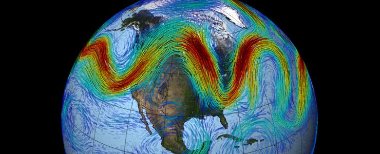
Francis, Meehl and some other meteorologists say the jet stream is in a rut, not moving nasty weather along. The high-speed, constantly shifting river of air 30,000 feet above Earth normally guides storms around the globe, but sometimes splits and comes back together somewhere else.
A stuck jet stream, with a bit of a split, explains the extremes in Texas, India, Alaska and the U.S. East, but not the typhoons, Francis says.
Other possible factors contributing to May’s wild weather: the periodic warming of the central Pacific known as El Nino, climate change and natural variability, scientists say.
Texas this month has received a record statewide average of 8 inches of rain and counting. Some parts of the Lone Star State and Oklahoma have gotten more than a foot and a half since May 1. The two states have gone from exceptional drought to flooding in just four weeks.
Texas state climatologist John Nielsen-Gammon attributes the heavy rainfall to an unusually southern fork in the jet stream, a stuck stationary front and El Nino, and says the downpours have probably been made slightly worse by climate change.

For every degree Celsius the air is warmer, it can hold 7 percent more moisture. That, Nielsen-Gammon says, “is supplying more juice to the event.”
While it is too early to connect one single event to man-made warming, scientific literature shows “that when it rains hard, it rains harder than it did 20 to 30 years ago,” says University of Georgia meteorology professor Marshall Shepherd.
As bad as the Texas flooding has been, the heat wave in India has been far worse — in fact, the world’s fifth-deadliest since 1900, with reports of the 100-degree-plus heat even buckling roads. And it’s a consequence of the stuck jet stream, according to Francis and Weather Underground meteorology director Jeff Masters.
When climate scientists look at what caused extreme events — a complex and time-consuming process that hasn’t been done yet — heat waves are the ones most definitely connected to global warming, Shepherd says.
The stuck jet stream has kept Alaska on bake, with the town of Eagle hitting 91, the earliest Alaska has had a temperature pushing past 90, Masters says.
And on the other end of the country, New York; Boston; Hartford, Connecticut; Albany, New York; Providence, Rhode Island; and Concord, New Hampshire, all have received less than an inch of rain this month and are flirting with setting monthly records for drought, he says.
El Nino is known to change the weather worldwide, often making things more extreme. This El Nino is itself weird. It was long predicted but came far later and weaker than expected. So experts dialed back their forecasts. Then El Nino got stronger quickly.
Some scientists have theorized that the jet stream has been changing in recent years because of shrinking Arctic sea ice, an idea that has not totally been accepted but is gaining ground, Shepherd says.
Katharine Hayhoe, a climate scientist at Texas Tech University, likens what’s happening to a stewpot: Natural climate fluctuations such as El Nino go into it. So do jet stream meanderings, random chance, May being a transition month, and local variability. Then throw in the direct and indirect effects of climate change.
“We know that the stew has an extra ingredient,” Hayhoe says, referring to climate change. “That ingredient is very strong. Sometimes you add one teaspoon of the wrong ingredient and boy, it can take your head off.”


